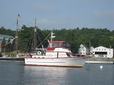
Departed I
 sle of Hope Marina southeast of Savannah this morning at 0900 at slack high tide, and had another uneventful day, crossing the Savannah River into South Carolina, then past Daufuskie Island (setting for the movie "The Water is Wide"), Hilton Head Island and through the Calibogue Sound and Port Royal Sound to Beaufort, South Carolina, where we anchored on the east side of the Beaufort River in about 10 feet of water at low tide.Had a relatively uneventful day with the tidal current playing its usual game of sometimes pushing faster and sometimes holding us back, until we reached a nice anchorage in Beaufort, SC, where we stopped for the day about 1630.
Last night at the marina while we were reading about 2100, we heard a rumbling engine sound tha
 t could easily have been a lumbering freight train - if there were train tracks anywhere close by. Instead, it was a tug pulling the dredge that had been working at Hell Gate and its attendant barges and pipes - all in all a 1800 foot long parade through the water attended by a couple of small tugs to help keep things lined up around bends and thru bridges. We passed it today as it was working it's way from the north end of Callobogue Sound out Skull Creek into Port Royal Sound.
As we we
 re coming out of the Calibogue Sound into Skull Creek we passed the tug Maverick towing a dredge, several smaller barges, and dredging pipe. This same 1800 foot rig had passed us about 2100 at the Isle of Hope. There are three smaller "helper tugs" accompanying the rig in order to help keep everything lined up when rounding bends in the ICW and going through bridges.
Tonight, as we were preparing dinner (filet mignon wrapped in bacon) the dredge train passed and stopped to wait for the tidal current to slack before proceeding under the Ladys Island Bridge in Beaufort.
Day: 52.1sm - 7H40M
Trip: 392.3sm - 56H20M
June 11, 2009
We weighed anchor
 at 0935 and were underway. Today we passed through many small rivers and land cuts (man made cuts connecting rivers) in the South Carolina low country south of Charleston. We anchored for the night at Toogoodoo Creek, about 25 miles south of Charleston.
During the late afternoon and into the early evening we watched as thunder heads built up in the west, and lightning flashed around the sky. It soon became apparent that we were not going to escape a major storm, so we made preparations by closing up the topside area, removing various items from around the boat, covering the flag and pennant and tieing the cover, and turning on the GPS so we could keep track of our position. Judy made this log entry for 2100: "Big thunderstorm came through - sever lightening - cloud to ground - Judy clocked wind at 56 knots (65mph) with hand held wind meter. Waves in the creek were substantial! Storm lasted about 20 minutes followed by cool air."
Day: 44.4sm - 5H15M
Trip: 436sm - 61H35M
June 12, 2009


Underway at 0845. Passed through Elliot Cut (on the west side of Charleston harbor) at 1230, and then toured the mega dock at the Charleston City Marina. By 1325 we had crossed Charleston Harbor and were back on the ICW channel heading northward.
We passed tug Maverick and her 1800 foot tow again this afternoon just north of Charleston.
We intended to anchor in Graham Creek (one of the places we seem to return to frequently), but with more storms predicted and two other boats already anchored in the small stream, we decided we'd go a little further north to another broad anchorage in Awendaw Creek. We had that creek to ourselves; although it is totally exposed to wind from any direction, it is at least 1/4 mile in any direction with 12-14 feet of water at low tide - perfect as far as we are concerned without regard to any winds the storm may throw at us. We let out 100 feet of chain, dug in the anchor, and then let out another 50 feet - all in anticipation of high winds again.
We had a little rain, some wind gusting to perhaps 20 knots, nothing more, but we were prepared!
Day: 64.2sm - 9H10M
Trip: 500.9sm - 70H45M
June 13, 2009
Underway at 09:15 and subsequently passed the North and South Santee Rivers, into Winyah Bay past Georgetown, SC, and the mouth of the Pee Dee River (the
 river about which Stephen Foster was writing - not the Suanee River) and into the Waccamaw River and its cyprus swamp. The river is lined on either side with cyprus trees so thick you cannot see more than 20-30 feet back into the swamp in most places. This continues until the river gets within 10 miles or so south of the Myrtle Beach area, where the land rises and development takes over for nature's beaufy. The trees, for the most part, are draped in Spanish moss (neither Spanish, nor a moss - actually a member of the pineapple family).
We passed tug Maverick and her tow again this afternoon. Learned that she and her 1800 foot train are heading to Norfolk. We probably won't see them again, as they run 24 hours a day (for the most part) while we stop at night, and are going to stop for two nights in Myrtle Beach.
We anchored for the night about 1.5 miles up Buck Creek, thick in the cyprus swamp. When we anchored the "tide" was flowing downstream at about 1.25 mph; the current never changed direction the entire night, but undoubtedly increased as the tide lowered and raised in the Waccamaw River (2.5 feet). We checked the chart plotter several times during the night, and the anchor was holding us in the same spot.
Day: 56.2sm - 7H30M
Trip: 557.1sm - 78H15M
June 14, 2009
The anchor was up at 0855 - it hadn't caught on any trees or limbs that floated by dur
 ing the night, and the trip line float was visible just below the surface when we were over the anchor itself. We were soon out of the beautiful cyprus swamp and into Myrtle Beach golf courses and ostentatious homes. We stopped at Barefoot Landing Marina, right behind a discount shopping mall, so Judy could rent a car and drive back to Savannah to attend her daughter's "white coat" ceremony at pharmacy school on Monday afternoon. In the meantime, I'm going to find someone to check out the forward air conditioning unit which is acting up.
Note: the next day I located a tech who came to the boat and diagnosed the AC problem as a bad fresh water pump. He'll order a new one and meet us in Carolina Beach to install it.
Day: 30.0sm - 4H05M
Trip: 587.1sm - 82H20M
June 15, 2009
Departed Barefoot Landing at 1010 after Judy returned the rental car, and at 1020 entered a stretch of the ICW called "The Rock Pile" because it is very narrow and is lined with the rock outcroppings from where the canal was blasted through the bedrock - it is an area where it is difficult to pass because of the width. At 1615 we entered the Cape Fear River at Southport, and had a good passage on the river despite threatening rain. By 1830 we had transited the river (without seeing Robert DeNero) and up Snow's Cut into the anchorage at Carolina Beach. It took us three tries to get the anchor to hold, and in the process the anchor windlass stuck in the "up" position (fortunately, after we had dropped the anchor for the final try).
Day: 59.8sm - 8H20M
Trip: 646.9sm - 90H40M
June 17, 2009
Called the air conditioning guy who came to the boat at Barefoot Landing, and he was ready to meet us at a dock on our way out of the anchorage. By 0945 a new water pump had been installed and we were on our way. We were delayed at Wrightsville Beach by a bridge that only opened on the hour to begin with, then had to delay for over 40 minutes waiting for an ambulance. That resulted in a late arrival at Mile Hammock Bay (Camp LeJeune, NC) where we were going to meet friends for dinner. As we turned into the bay from the ICW it was hard not to notice the group of Army LCMs parked at the head of the bay on the dock where we would have to land to go ashore to meet our friends; as soon as we anchored we put the dinghy in the water and I went over to check with the Army to see if it was OK if we stayed - it wasn't! So we called our friends to cancel dinner, and had to find another place to spend the night. By this time it was starting to get dark, and we decided the easiest thing to do would be to backtrack a few miles and stay at a marina (where we could also buy fuel at a good price). Turned out to be a good decision, but we missed dinner with our friends whom we had been looking forward to seeing. We'll get together on our trip south.
Day: 58.9sm - 9H40M
Trip: 705.8sm - 100H20M
June 18, 2009
When the marina opened at 0700 we let them know that we were the extra boat - we had come in well after the marina closed for the day - and that we needed fuel and ice. We took on 200.1 gallons of diesel at the lowest price per gallon we'd seen on the waterway; we had travelled 132 hours since our last fill-up, so we could calculate that we were burning 1.5 gallons per hour and averaging 4.5 miles per gallon - every bit as good as I had hoped for after having the injectors tuned and adjusting the valves before we left home.
We got underway at 0820, went through Moorehead City/Beaufort, NC, at 1520, and anchored in Cedar Creek at mile 190 at 1710 along with several other boats.
Day: 60.9sm - 8H50M
Trip: 766.7sm - 109H10M
June 19-20, 2009
We left Cedar Creek at 0750 on Friday, anchored in the Pungo River that evening, and on Saturday transited the Alligator River-Pungo River Canal and the length of the Alligator River. When we got to the mouth of the Alligator River it was mid-afternoon, and we had Albermarle Sound and another four hours of running ahead of us, so we anchored on the western side of Alligator River at Sandy Point for the evening. Albermarle Sound is a notoriously rough body of water when the wind is blowing more than 10-15 knots from either west or east, so we were hopeful that an early start the next morning would result in a calmer passage. We planned to be underway by 0600.
Trip 874.7sm - 124H20M
June 21, 2009
We were underway at 0610 and Albermarle Sound had already started acting up. Our course was to the mouth of the Pasquatank River and to Elizabeth City - a good 4-5 hours away on a good day! We "battened down the hatches" so to speak and tied everything down that was moveable, bolted the saloon table to the floor, laid down the lamp and books, and closed the doors and windows to prevent spray from entering the boat. The passage wasn't too bad - we encountered 2 foot seas off the port bow, and a little spray, but it was still "bumpy."
We passed through the Elizabeth City Bridge at 1100, and by 1330 we were into the South Mills Lock at the south end of the Dismal Swamp Canal. There were four other boats in the lock with us, and we were the last ones, so we decided we'd just spend the night on the bridge fenders after going through the lock and the bridge. Places to tie up in the canal are limited, and with other boats ahead of us we were concerned that we wouldn't be able to find a place.
We had a really good pizza for dinner (purchased at the gas station next to the bridge) and stocked up on ice.
Day: 54.7sm - 8H00M
Trip: 929.4sm - 132H20M
June 22, 2009
We departed the South Mills bridge at 0730 on our way to a small dock near a Mexican Restaurant at Deep Creek (near the north end of the canal and about 21 miles from the south end). We had allowed plenty of time for the trip at 6 mph, but when we started off I thought I'd push up the rpms a bit to make sure we could cover the distance a little faster than we had planned. When I increased the rpms, the boat speed did not increase commensurately. We began worrying that there was something wrong with the transmission. Increasing the rpms more didn't help - the speed stayed about 6.4 mph, and fluctuated between 6..0 and 6.9 mph. We considered that the gps was acting up, but two different gps units showed identical information - perhaps it was the gps satellites - perhaps we were under attack and the gps constellation had failed? I consulted the Trawlers-and-Trawlering list, and the one theme that made the most senst (hoped for solution) was that the hydrodynamics of the boat moving through the shallow and confined width of the canal was restricting the boat's speed through the water - several people came up with this explanation based on their past experience. The more we thought about it, the more sense it made. On our previous passages through the canal we had never tried to go faster than about 6mph, so we had never experienced the problem.
Without a definitive solution to the problem we were experiencing, we were able to tie up to the little dock by the Mexican Restaurant at Deep Creek, did some shopping, and waited for the next passage through Deep Creek Bridge and Lock at 1330. When we got through the lock about 1400, I increased the rpms and Sanderling's speed picked right up to where it should be! The problem was the hydrodynamics of the canal. Whew!
We passed through Norfolk with it's busy port and the Navy base, and anchored in the Phoebus Channel next to Old Point Comfort.
When we passed Hospital Point we passed mile zero of the ICW, so we are now switching to nautical miles instead of statute miles, since statute miles are used only on man-made canals and some rivers whereas nautical miles are used on the ocean and other major bodies of water.
Day: 44.4sm - 6H45M
Trip" 973.8sm - 139H05M
June 23-24, 2009
We left Phoebus Channel and anchored inside Sandy Point on the Great Wicomico River (just south of the Potomac River) for the night, then the next day crossed the mouth of the Potomac (it takes forever) and into the Patuxent River (Solomons) with the tidal current (and river currents) running against us the entire way. We anchored in Mill Creek just above Solomons and across the river in California, Maryland (at least that's the town/city where we think we're located - it's a little difficult to tell from a map). We'll stay here until Friday when we're heading into the marina at the Navy Recreation Center Solomons for our family reunion and will stay there for a week or more.
Trip: 941nm(1081.8sm) - 155H50M