Sunday, October 18, 2009

Elizabeth City, NC to Charleston, SC

October 8, 2009

The forecast 
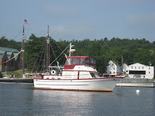
was good and we departed Elizabeth City at 0645 (as soon as we could clearly see the surface of the water). On the way down the Pasquatank River we passed the large wooden structure where most of the blimps in the US are built - the photo shows two blimps tethered outside. A number of other boats departed at about the same time, and by the time we had crossed the calm Albermarle Sound there was quite a parade of boats crossing the shallow area entering the Alligator River from both Elizabeth City and Coinjock (the main ICW route). The Alligator River stretches interminably to the south, then takes a dog-leg to the west, and finally connects with the Alligator-Pungo Canal. We frequently stop at an anchorage after passing through the Canal, in the headwaters of the Pungo River, but this time kept going another 15 miles or so to Pungo Creek, just south of Belhaven, NC - what a beautiful spot, and we could see the Milky Way that evening as there wasn't a city within miles to lighten the sky.

Day:87.4sm - 11H45M
Trip: 1854.1sm - 271H15M

October 9-10, 2009 (Pungo Creek to Mile Hammock Bay)

We departed Pungo Creek with winds forecast for 15-20 gusting to 25 in the afternoon. By the time we traversed the Neuse River and made the turn toward Beaufort/Morehead City, NC, the winds had picked up. We passed Cedar Creek (a familiar anchorage) to get to Morehead City and possibly Swansboro at the western end of Bogue Sound, but decided the higher winds would make Bogue Sound (totally unprotected from the south and we couldn't get a forecast specific to the sound) too rough, and were concerned that the winds would also make Morehead City waters rough, so turned around and anchored in Cedar Creek for the rest of the afternoon and night. It was a short day.

Day:56.3sm - 7H30M
Trip: 1910.4sm - 278H45M

The next day (October 10) winds had slacked off slightly, and we still couldn't get a good forecast for Bogue Sound itself, so we decided that we'd give it a try and turn around again and find a spot in Morehead City, if necessary. As we turned the corner at Morehead City, we passed alongside this freighter unloading at the dock.


Turned out the sound was not a problem, and we made it to Mile Hammock Bay (Marine base Camp Lejeune, NC) by late afternoon. We tried to arrange dinner with retired Marine Corps friends there, but they had prior commitments - one of these trips we'll get together, again.
Several of the boats anchored in Mile Hammock Bay at sunset

Day: 58.7sm - 7H55M
Trip: 1969.1sm - 286H40M

October 11-14, 2009 Mile Hammock Bay to Charleston, SC

The next four days were relatively uneventful - no winds to be concerned about, plenty of places to anchor - other than the low bridges with fixed opening schedules that we had to have opened for us (as well as other boats, doing the same) before we could pass. As it turned out, we made all of the scheduled openings without having to wait more than a few minutes, so we made good time.

Freighter heading up the Cape Fear River


Anchorage about 20 miles north of Charleston harbor

Judy had to return to Florida for some scheduled American Heart Association meetings and to work the upcoming weekend at her hospital in Sebastian. The issue became how far could we get before she had to rent a car and drive home. We first looked at Georgetown, SC, but they had a wooden boat show over the weekend and we couldn't get a slip, and it would have meant that we would have needed to stop earlier than necessary. We didn't have enough time before her departure to get as far as Beaufort, SC (closer to home for the final push). So Charleston came up as the logical place to stop while Judy made the trip back to Florida.

Sanderling, Julie, Khepera and I are now in Ashley Marina in Charleston, SC. As soon as we arrived late Wednesday morning Judy got a rental car and drove back to Florida. She will return on Monday and we'll depart Tuesday morning (early) to get as far south as we can before she has to return to Florida again for more scheduled meetings. We've both had to reschedule some appointments or miss some meetings, but that's the way it is when you're cruising.

I've been working on some minor boat-related projects, reading, and meeting up with some crujising friends who live in Charleston. Last night (Friday) we went to the Charleston Symphony to hear a Beethoven concerto and symphony; tonight I've been invited to their lovely home in the heart of old Charleston for dinner. I also need to do some grocery shopping before departing, and will do that today or tomorrow via the marina's courtesy van.

We depart Tuesday. Our planned itinerary will take us to Beaufort, SC; Savannah; Frederica River; Fernandina Beach; St. Augustine; New Smyrna Beach; and finally to Manatee Cove Marina.

Trip: 2196.2sm - 317H14M

Wednesday, October 7, 2009

Goodbye Baltimore - Hello ICW

September 30, 2009

After delaying a day for uncomfortably high wind on the Chesapeake, we departed Baltimore and Henderson's Wharf Marina today to head south to Florida. Chesapeake Bay was delightfully calm, and we made it to Solomons by 1645 and into took a mooring at Zahnizer's Marina. There were several boats anchored out, apparently waiting for Trawler Fest to start on Friday. A HUGE boat at Zahnizer's dock was the Argyll at 150 feet and 4 decks above the waterline. She is huge, and our stern was about 40 feet off her port side. I'm sure other boats in the harbor would have had difficulty seeing "little" Sanderling against the backdrop of this monstrosity! Check out "Argyll luxury yacht charter" to see it for yourself.

Day: 65.7nm - 9H35M
Trip: 1390.8nm - 234H00M

October 1, 2 & 3, 2009

Departed Solomons at first light (about 0645) immediately after Argyll left her dock. There were a number of other trawlers (as well as other types of boats) departing and all headed south. We were hoping for another good day on Chesapeake Bay, but hoped to at least get south of the Potomac River before encountering some predicted head seas in the lower part of the Bay. As it turns out we had another beautiful day cruising down Chesapeake Bay - at one point in the mid afternoon the water was like glass, something that is very unusual on the bay. We anchored for the night a little after sundown in the Phoebus Channel immediately north of Norfolk. The wind came up a little during the night to give us a little rocking, but nothing like we'd experienced in this location on prior occasions.

The next morning (Octobe 2nd) we took the dinghy 1/4 mile or so to the Army-operated marina at Old Point Comfort to go ashore and tour historic Fort Monroe and see where Jefferson Davis was imprisoned for several years after the Civil War.

In the early afternoon we made a short cruise back around the I-64 tunnel entrance and up the Hampton River to an anchorage just north of a number of large marinas and under a bridge with 29 feet clearance. We had no sooner dropped anchor when we saw Argyll (the luxury yacht from Solomons) pulling up to the town docks. She didn't dominate the waterfront like she did in Solomons, but it was still hard to miss! We checked out the free dinghy dock at the town docks, walked around a little, then went back to Sanderling for the rest of the afternoon and evening.

On October 3rd friends Norm and Nancy came aboard around noon. We caught up with each others' goings on since we saw them last February in Florida, got them settled in to their quarters in the V-berth, and then went ashore for dinner at a local restaurant.

Day: 3.3nm - 0H35M
Trip:

October 4, 5 & 6, 2009 - The Great Dismal Swamp

October 4th began our trip into the IntraCoastal Waterway (ICW) which will take us all the way to our home in Florida. We started at 0830 after breakfast and cruised across Hampton Roads and past the sprawling Navy base at the northern end of the Elizabeth River. There were a number of aircraft carriers, cruisers and submarines docked at the base, in addition to several Military Sealift Command (MSC) ships taking on cargo. We then passed mile zero of the ICW and continued up the Elizabeth River. We stopped for fuel (260 gallons) at the Ocean Marine Center (known for it's good fuel prices) where we also filled our water tanks. We then continued up the Elizabeth River through Norfolk and Portsmouth, Virginia, with their very active waterfronts. Even though it was Sunday there were a few tugs and other boats out performing their day's work. We seemed to be one of a few pleasure boats heading south. The bridges were all open, although we did have to wait 10-15 minutes at one highway bridge for a tug to position some work barges against the fenders where they were working.

We arrived at Deep Creek Lock leading into the Great Dismal Swamp at 1305, and were let into the lock at 1325; by 1400 we had been raised eight feet to the level of the canal and had our lines tied to Elizabeth's Dock just inside the northern lock in the Great Dismal Swamp.

We walked around the park adjacent to Elizabeth's Dock, walked to the small town and purchased a few groceries, then walked back to Sanderling where we just took it easy for the rest of the afternoon. We then walked back into town in the evening for dinner at a Mexican restaurant.

On October 5th we departed Elizabeth's Dock in order to go through the bridge about a mile from the lock at 0830 when it opened for a northbound boat departing the canal. We continued 15 miles through the straight and narrow canal, with mostly swamp land and a few farm fields on the west (right/starboard) side, and a few trees and highway 17 on the east (left/port) side. We arrived at the North Carolina Visitors' Center and tied to their free dock at 1125. We had a very enjoyable day there, exploring the area around the Visitors' Center and the nearby North Carolina Dismal Swamp Park. A floating swing bridge leads from the visitors' center across the canal to the park and an extremely well-presented display of the history and other things related to the canal and the Great Dismal Swamp. We walked the boardwalk out into the swamp, and talked with the park rangers.

On Tuesday, October 6th, we departed the visitors' center at 0950 and arrived at the South Mills Bridge and Lock at 1035 where we tied to the bridge fender to wait the opening of the bridge at 1100. By 1055 we were through the bridge and into the lock. By 1120 we had been lowered eight feet to the level of the Pasquotank River on the south end of the canal and were heading out of the canal to Elizabeth City, about 16 miles down the river from the South Mills Lock. By 1400 we had lines to the free bulkhead at Elizabeth City - the City of Hospitality. Believe me, this city lives up to its motto. We had no sooner tied up than a lady from the Welcome Center had come to the boat and was telling us about the area, it's many restaurants, art gallery, museum, and the wine and cheese party they throw for boaters at 1630 in the afternoon. We had plenty of time to walk through the museum just across the street from where we are located, and still attend the wine and cheese event where we met a number of other boaters who had arrived recently. Then we went to dinner at a local restaurant where we've eaten when we've been here before.

Unfortunately, the weather forecast for Wednesday for Albermarle Sound, which we must pass across on our way south, was not good for comfortable cruising. Another complication was the fact that the Alligator River Bridge, across the northern end of the Alligator River, was being worked on and wouldn't be opening until 1700 on Wednesday. We checked the forecast several times throughout the day and into the evening, and it didn't get any better, so we decided to remain in Elizabeth City for another day until weather improved on Albermarle Sound and the bridge repairs had been completed. As it turns out, only one boat left on Wednesday heading south.

Day: 23,6sm - 3H10M
Trip: 1714.6sm - 259H30M